Adelaide Airport (ADL)
City Orientation and Maps
(Adelaide, Southern Australia (SA), Australia)
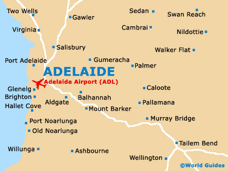
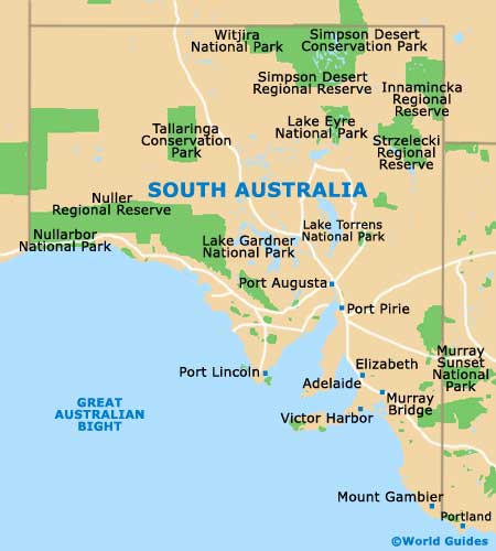
The city of Adelaide lies on the southern side of Australia, next to the Great Australian Bight and the Indian Ocean. Situated in the state of South Australia, Adelaide is an attractive coastal city, located close to a number of notable towns, such as Port Lincoln to the west, Port Augusta to the north, Mildura to the east, and both Horsham and Mount Gambier to the south-east. Also close to Adelaide, Victor Harbour lies on the Fleurieu Peninsula, with the nearby Waitpinga Beach offering good surfing conditions. Adelaide Airport (ADL) is within easy reach of the city centre, being located a few minutes to the west.
Central Adelaide is organised as a grid system with a number of large public squares. King William Street is Adelaide's main artery and dissects much of the city, being lined with many important buildings and landmarks. Lying at the very heart of central Adelaide, Victoria Square is home to the Glenelg tram terminus, several bus stops and a popular rank of taxi cabs. To one side of Victoria Square you will find Franklin Street and the city's main bus station.
Adelaide Airport (ADL) Maps: Important City Districts
Located to the north of the Glenelg district and on the western side of the city centre, Adelaide Airport (ADL) is within easy reach of many major neighbourhoods and areas. These include Henley Beach, Port Adelaide, Brighton and the city centre, which is home to the Chinatown district, the Town Hall and countless historic Victorian buildings.
Those planning to party in Adelaide should head for Rundle Street, which is a busy area, known for its socialising. With a range of entertainment, available both day and night, highlights along Adelaide's Rundle Street include restaurants, cinemas, bars, nightclubs and to the west, Rundle Mall, where you will find a large collection of shops and department stores. Hindley Street lies off Rundle Mall, together with its numerous strip clubs and buildings from the University of Adelaide.
The stylish North Terrace is situated to the north and contains many striking buildings, such as the Adelaide State Parliament complex, a large casino, the Adelaide Convention Centre, part of the university campus, the city's botanical gardens and also a busy train station. Further north are Adelaide's attractive North Parklands, together with the Festival Centre, which is located alongside the River Torrens and next to Elder Park.
Australia Map

South Australia Map
Adelaide Map